
This post first appeared on Risk Management Magazine. Read the original article.
For the second year in a row, wildfires have wreaked havoc in California, punctuated this year by some of the largest and most destructive fires in state history. While wildfires are an annual threat in California, the past two years seem to have brought a continuous procession of fires of greater frequency, scale and destructive intensity than in previous seasons. While it is difficult to determine with any certainty what, if anything, may have changed, the level of wildfire activity in 2017 and 2018 underscores the importance of planning for and addressing the evolving risks to land and property.
Two Years of Wildfires
The severity of a given wildfire season in California is typically dependent on a number of factors, including weather, temperature, wind speed and direction, and the presence of combustible material. On the heels of a long-running drought in the state, the winter of 2017 was one of the wettest on record, with plenty of rain in January and February that caused trees and plants to proliferate in the spring, then dry out in the hot summer. Combined with an estimated 129 million trees that had died due to drought conditions and bark beetle infestations in the previous year, this abundance of fuel helped create conditions that resulted in one of the most destructive wildfire seasons in a decade.
In 2017, more than 9,000 separate wildfires devastated nearly 1.4 million acres of land from Sacramento to San Diego, affecting thousands of structures and resulting in an economic toll of up to $180 billion. October saw 250 wildfires in Northern California that burned more than 245,000 acres and accounted for more than $9.4 billion dollars in insured property losses, the costliest group of wildfires on record. In and around Santa Rosa, the Tubbs fire alone killed 22 people, destroyed more than 5,500 structures, and resulted in more than $2.8 billion in damage, making it the most destructive single wildfire in the state’s history. In December, wildfires ignited in Southern California, including the Thomas fire in Ventura County, which burned in excess of 280,000 acres, becoming (at the time) the largest recorded wildfire in state history.
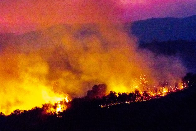
Thus far, the 2018 wildfire season has proven to be almost as destructive. The rash of fires in California this year has largely been concentrated in the northern part of the state, where the Carr fire became the sixth-most destructive in state history after it rampaged through the city of Redding and Shasta and Trinity counties. The heat of the fire was intense enough to create fire whirls, also known as fire tornados.
On July 26, the National Weather Service confirmed that such a fire whirl developed with a wind speed of 143 mph—the equivalent of a F-3 tornado—with a vortex that extended seven miles high. By Aug. 28, the blaze had burned more than 229,000 acres, destroyed some 1,600 structures and killed eight people. Insured losses from the fire could be as high as $1.5 billion.
Two blazes in late July, the River and Ranch fires, created another massive inferno in Northern California. Collectively known as the Mendocino Complex fire, this enormous conflagration had burned an area the size of Los Angeles by early August. By the end of the month, the Mendocino Complex fire had grown to more than 450,000 acres, dwarfing the Thomas fire to set another record for the largest wildfire in the state.
Beyond the Wildland-Urban Interface
As wildfires become more frequent and widespread, the zone known as the wildland-urban interface has increasingly become the battleground when it comes to severity of damage to property and risk to life. As defined by the U.S. Forest Service, the wildland-urban interface is where “humans and their development meet or intermix with wildland fuel.” Typically these areas are the most vulnerable to wildfire damages due to their proximity to combustible vegetation.
Experiences from the 2017 Santa Rosa region fires have also highlighted the vulnerability of urban regions outside of defined wildland-urban interface zones, including densely populated residential and commercial developments, to wind-borne embers flying long distances. The increased severity of the winds this year—which reached speeds of up to 70 miles per hour this season as compared to the typical 35 to 40 miles per hour—caused embers to fly over fuel breaks and natural fire barriers, highlighting the risk to regions that may not have had to consider it before. This unpredictability is making the wildfires more difficult to control, as they move at speeds of up to 14 miles per hour, frequently change direction, and unexpectedly jump across waterways and freeways.
From a risk perspective, the scale and severity of wildfires is increasingly clashing with an expanding urban footprint where the risk posed by the mix of human development and vegetation may not be well understood by current modeling. New exposures due to fuel load, wind velocities and developments built on cleared wildland will all require additional analysis to understand the regional implications for property risk.
New Technologies for Wildfire Preparedness
Technology has begun to play a larger role in managing wildfire risks by providing new tools to enhance proven mitigation strategies like creating a defensible space around a building, hardening the structure against fire, and developing a business continuity plan. Read more from Risk Management about some of these latest advances.
Post-Fire Rebuilding Efforts
Because wildfires can affect entire regions, towns and communities, rebuilding through individual building and fire authorities can be challenging. Provisions for rebuilding within a prescribed wildland-urban interface often require improvements such as treated timber, fire-retardant roof materials and heat-resistant skylights, which would not ordinarily be considered in non-wildland zones.
It is also not unusual for local authorities to promulgate new code provisions for repair or rebuilding in the wake of a disaster. Mandating fire protection features such as fire sprinklers and alarms or heat-resistant materials are common post-fire building code adjustments, particularly for those properties located within pre-fire wildland-urban interface zones.
In more remote areas, where properties are clearly in wild terrain, access roads and fire protection are often reviewed for new compliance standards, such as ensuring they are sufficient to bear the weight of fire vehicles. Understanding the underlying code requirements for remote areas and having a broad experience with “non-urban” infrastructure and buildings are both helpful when dealing with the building and fire authorities to determine the technical standards for code compliance.
Stakeholder Strategies
Stakeholders, including owners and insurers, have divergent tracks but ultimately share a common goal: minimizing damage from wildfires. Owners can employ strategies to develop or maintain properties to mitigate the peril of fire, and insurers can better understand the unique and evolving risks associated with both properties located within the wildland-urban interface and, importantly, those that appear to be “safe” but may only be one flying ember away from disaster.
Owners can proactively manage and minimize fuel load by regularly clearing dead, dry growth and underbrush and removing flammable materials from in and around buildings. The California Department of Forestry and Fire Protection (CAL FIRE) recommends that homeowners maintain at least 100 feet of defensible space around homes and buildings where vegetation and debris are cleared to prevent fire from spreading. Buildings in wildland-urban interface zones should be constructed of fire-resistant materials or, if they were built prior to the most recent codes, the structure should be “hardened” using materials such as:
- metal or tile (rather than shingled) roofs
- ignition-resistant or non-combustible eaves and soffits
- baffles or metal mesh coverings for vents
- smaller windows and dual-paned windows, with at least one pane of tempered glass
- non-wood siding, stucco or fiber cement
- screened rain gutters and chimneys
Some other preventative measures enacted in the last two decades include constructing fire-retardant roofs with no exposed eaves and incorporating non-plastic materials and natural fire breaks into the surrounding landscape. After 2007’s devastating wildfires, California enacted the 2007 California Building Code to cover new buildings located in any fire hazard severity zone and establish wildland-urban interface (WUI) fire area building standards. The new code added many fire-protection measures and was accompanied by a WUI Approved Products Handbook that included a list of building products approved for use in wildland-urban interface zones, including windows, doors, exterior siding, roofing and decking.
As wildland-urban interface zones can change over time, particularly after a significant fire event, it is wise for owners to verify the applicable codes and requirements for their properties in locations where human development mixes with fuel load. Owners of such properties should also take into account that their semi-remote locales can be a hindrance to effective fire suppression, further increasing their vulnerability.
Although it is ultimately impossible to predict how a wildfire will behave, the sheer number of variables that can influence its severity and the past two wildfire seasons all mean that the threat has never been greater. Preventative measures coupled with code compliance can go a long way toward keeping communities and buildings safe.